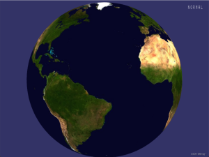

OSGEARTH3 加载一个地球
方法一: 读取*.earth文件
读取*.earth文件加载,改文件格式是xml形式,每个节点代表指定的图层:
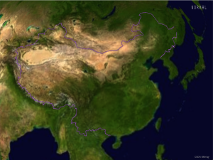
- FreeEarth_flat_simple.earth文件内容,加载一个基础图层,即使用一张全球大图作为底图:
world.tif的路径是相对于*.earth文件的。
<!--
osgEarth Sample - simple image
-->
<map name="Demo: simple image">

  <image name="default" driver="gdal">
    <url>../world.tif</url>
    <shader>
      <uniform name="gamma" value="1.5"/>
      <![CDATA[
            #pragma vp_entryPoint gammaCorrection
            #pragma vp_location   fragment
            uniform float gamma;
            void gammaCorrection(inout vec4 color)
            {
                color.rgb = pow(color.rgb, vec3(1.0/gamma));
            }
          ]]>
    </shader>
  </image>

</map>
- 代码内加载*.earth文件
- 初始化GDAL;
- 初始化OSGEARTH;
- 加载地球, 读取earth文件
- 运行
#include <osgEarth/Common>
#include <gdal_priv.h>
#include <ogr_api.h>
#include <ogr_core.h>
#include <ogr_feature.h>
#include <ogr_geometry.h>
#include <ogrsf_frmts.h>

#include <iostream>
#include <osgViewer/Viewer>
#include <osg/Vec3d>
#include <osg/MatrixTransform>
#include <osgDB/ReadFile>

#include <osgEarth/EarthManipulator>
#include <osgEarth/MapNode>
#include <osgEarth/GDAL>
#include <osgEarth/OGRFeatureSource>
#include <osgEarth/FeatureImageLayer>
#include <osgEarth/GeoTransform>

int main(int argc, char** argv)
{
	OGRRegisterAll();
	GDALAllRegister();
	CPLSetConfigOption("GDAL_DATA", "../../Data/gdal_data");
	CPLSetConfigOption("CPL_DEBUG", "YES");
	CPLSetConfigOption("CPL_LOG", "../LOG/gdal.log");

	osgEarth::initialize();

	{
		// map
		osg::Node* globe = osgDB::readNodeFile("../../Data/3d-data/Data/earth/FreeEarth_flat_simple.earth");
		osgEarth::MapNode* mapNode = osgEarth::MapNode::get(globe);

		// viewer
		osgViewer::Viewer viewer;
		viewer.setSceneData(mapNode);

		// manipulator
		osg::ref_ptr<osgEarth::Util::EarthManipulator> mainManipulator = new osgEarth::Util::EarthManipulator;
		viewer.setCameraManipulator(mainManipulator);

		// run
		viewer.setUpViewInWindow(100, 100, 800, 600);
		viewer.run();
	}

	return 0;
}
方法二: 图层加载
直接通过代码的形式创建layer, 进行加载:.
world.tif路径相对于exe.
1. 初始化GDAL;
2. 初始化OSGEARTH;
3. 加载地球.
4. 加载基础图层
5. 运行
#include <osgEarth/Common>
#include <gdal_priv.h>
#include <ogr_api.h>
#include <ogr_core.h>
#include <ogr_feature.h>
#include <ogr_geometry.h>
#include <ogrsf_frmts.h>

#include <iostream>
#include <osgViewer/Viewer>
#include <osg/Vec3d>
#include <osg/MatrixTransform>
#include <osgDB/ReadFile>

#include <osgEarth/EarthManipulator>
#include <osgEarth/MapNode>
#include <osgEarth/GDAL>
#include <osgEarth/OGRFeatureSource>
#include <osgEarth/FeatureImageLayer>
#include <osgEarth/GeoTransform>

int main(int argc, char** argv)
{
	OGRRegisterAll();
	GDALAllRegister();
	CPLSetConfigOption("GDAL_DATA", "../../Data/gdal_data");
	CPLSetConfigOption("CPL_DEBUG", "YES");
	CPLSetConfigOption("CPL_LOG", "../LOG/gdal.log");

	osgEarth::initialize();

	{
		// map(empty)
		osg::ref_ptr<osgEarth::Map> map = new osgEarth::Map;
		osg::ref_ptr<osgEarth::MapNode> mapNode = new osgEarth::MapNode(map);

		// base layer
		osg::ref_ptr<osgEarth::GDALImageLayer> baselayer = new osgEarth::GDALImageLayer();
		baselayer->setURL("../../Data/3d-data/Data/world.tif");
		map->addLayer(baselayer);

		// viewer
		osgViewer::Viewer viewer;
		viewer.setSceneData(mapNode);

		osg::ref_ptr<osgEarth::Util::EarthManipulator> mainManipulator = new osgEarth::Util::EarthManipulator;
		viewer.setCameraManipulator(mainManipulator);

		// run
		viewer.setUpViewInWindow(100, 100, 800, 600);
		viewer.run();
	}

	return 0;
}
© 版权声明
文章版权归作者所有,未经允许请勿转载。
THE END


![[转]我国CAD软件产业亟待研究现状采取对策-卡核](https://www.caxkernel.com/wp-content/uploads/2024/07/frc-f080b20a9340c1a89c731029cb163f6a-212x300.png)